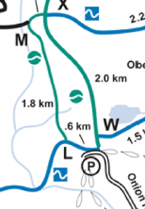
Beginner Route
Self Guided Ski Routes for every level
Our Backyard in Tofte, Minnesota hosts epic ski and snowshoe adventures for every level. The Sugarbush trail system is aptly named for the massive Maple trees that dominate the landscape along with Cedar, Balsam Fir, and Black Spruce. Take in the scenery at the pace right for you. Whether you are getting out for the first time or looking to push your limits, the Sugarbush has something for you. Check out these recommended loops, all within a 15 minute drive from the shop. Link to Full Map
Beginner: This route is great for new skiers learning the basics. From the Onion River Rd parking lot, ski clockwise to L then head north to M. From M head east to X then south back to the parking lot. You can even do laps on this route as you build comfort before progressing to more advanced terrain. (5K)
Intermediate:
This route is an introduction to more technical skiing. Even the green trails that access the homestead loop contain steeper trails and tighter turns than the onion river road. From the Britton Peak Trailhead ski east through A, B, C, D, F to H. Then proceed to the Homestead Loop, sking clockwise to J, I then back to H. From here, head back to the trailhead where you can extend the route by adding a few additional detours. (10K)
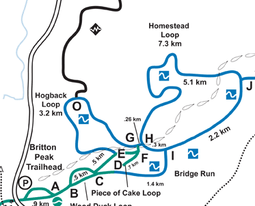
Intermediate Route
Advanced:
The picnic loop is no picnic, though it’s long enough to require a lunch break. Depart from Onion River Road and proceed to Junction M, where you will access the picnic loop. Ski this trail west then south to take Hogback to upper Homestead then the Oberg Connector to return to the start of the route. (25K)
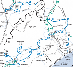
Advanced and Marathon Route
Marathon:
This route will be the most extensive experience of what the Sugarbush has to offer. Start at the Moose Fence trailhead and ski out to the Picnic Loop and go west to the Hogback Loop then east through the connector route to the east Oberg Loop. Then head back to the start via the east Picnic Loop and down the connector to return to Moose Fence. (43K)
Snowshoe Routes:
With three summit trails accessible from two trailheads, the hardest choice will be
where to start. No matter what you choose, you are guaranteed scenic views that will inspire awe and give you a good workout along the way. Link to Full Map
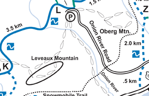
Map 1: Beginner and Advanced Route | Endurance Route
Beginner: Start from the Onion River Road parking lot and head east on the Superior Hiking Trail. Take the spur trail to Oberg Mountain and follow the loop to take in awe inspiring scenery in every direction. (2.2 Miles)
Advanced: From Onion River Road parking lot, head west on the Superior Hiking Trail toward the prominent ridgeline above Lake Superior. Follow the spur trail to make a loop on the ridge traversing Leveaux Mountain. Take in the views but make sure to follow the trail back to the parking lot instead of continuing west on the SHT. (4 miles)
Endurance:
Endurance is associated with both Map 1 and Map2
Summit all three high points of Oberg, Leveaux and Carlton in a single day. Remember to monitor snow conditions and adjust projected travel speeds accordingly. If breaking trail in deep snow, travel time will increase dramatically as will the level of exertion. Take plenty of water with adequate insulated so that it does not freeze. (9.2 Miles)
Intermediate: From the Britton Peak Trailhead, cross the Sawbill Trail and head West on the Superior Hiking Trail. When you reach the trail registry, follow the switchback spur trail north to the summit. Take your time to find views in every direction. On the return trip take the detour to Tofte Peak for even more scenery of Lake Superior and the National Forest. (3 Miles)
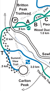
Map 2: Intermediate Route| Endurance Route

